+86-15889090408
[email protected]

Tibet, often referred to as the “Roof of the World,” is renowned for its breathtaking landscapes, from the towering peaks of the Himalayas to the expansive plateau and sacred lakes that dot its vast expanse. But beyond these awe-inspiring natural features, Tibet’s rivers are perhaps its most vital and defining elements. They are not only the lifeblood of the Tibetan people but also the arteries that nourish much of Asia, flowing into some of the continent’s most populous and ecologically important river systems.
Tibet’s rivers are the result of an intricate interaction between the region’s unique topography, climate, and glaciers, which provide a constant flow of fresh water even in this high-altitude, arid landscape. These rivers have played a central role in the culture, agriculture, and spiritual life of Tibet for centuries, while their importance extends far beyond Tibet’s borders, serving as the primary source of water for millions of people in neighboring countries such as India, Nepal, China, Bangladesh, and Southeast Asia.
In this blog post, we will explore the major rivers of Tibet, their sources, courses, ecological importance, and the challenges they face in the modern era, such as climate change and increasing human demands.
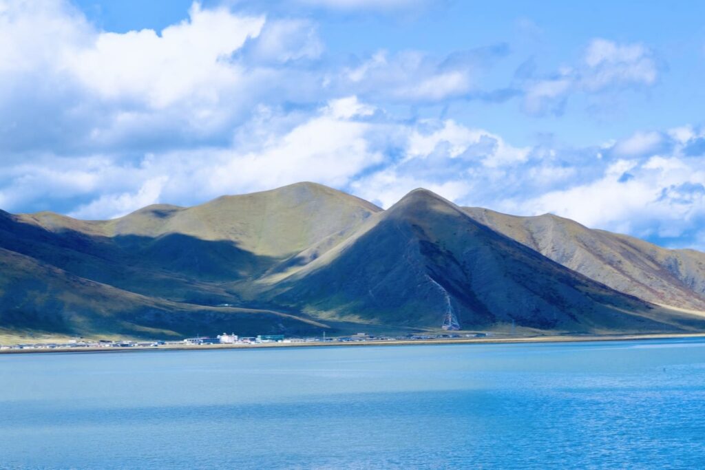
Tibet is the origin of four of Asia’s most significant rivers — the Yarlung Tsangpo (Brahmaputra), Indus, Mekong, and Yangtze. These rivers are crucial not just for Tibet’s ecological and spiritual landscape, but also for the millions of people who depend on them in countries far beyond Tibet’s borders. These rivers are sometimes referred to as the “Asian Water Tower,” as they provide water for some of the largest and most populous river systems in the world.
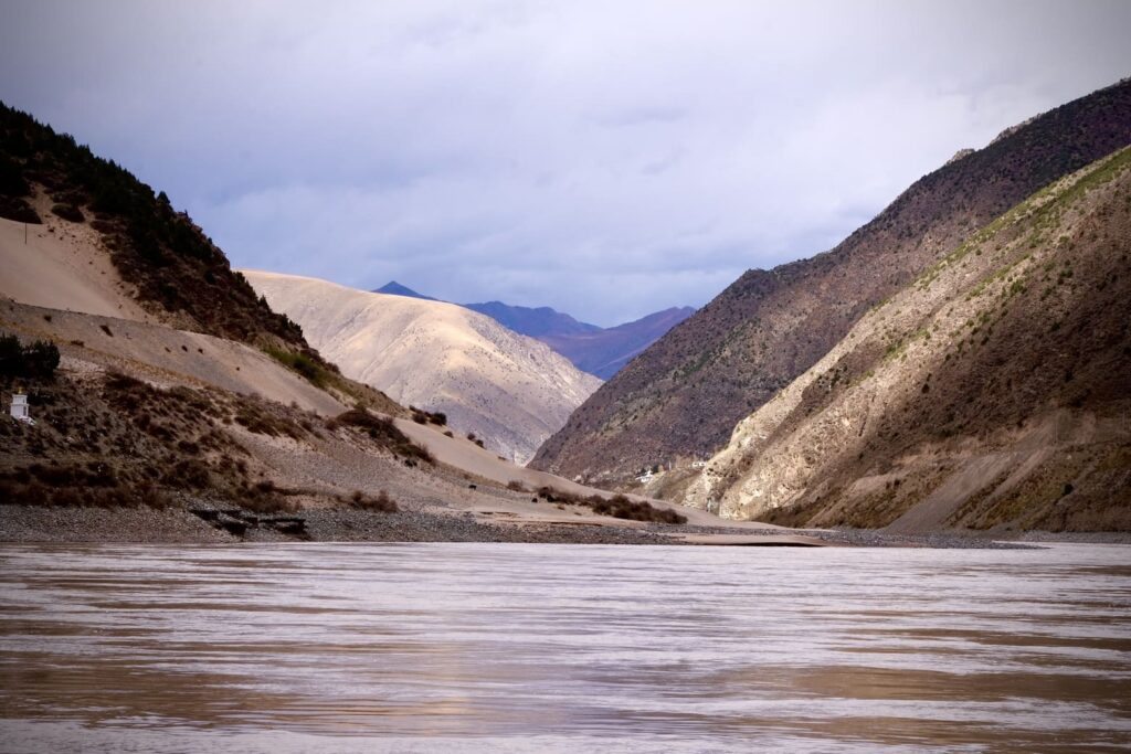
The Yarlung Tsangpo, known as the Brahmaputra in India, is one of the most significant rivers originating in Tibet. It is the longest river in Tibet and plays an essential role in the ecosystems of the Indian subcontinent and Bangladesh.
The Yarlung Tsangpo originates from the Angsi Glacier in the Tibet Autonomous Region (TAR) of China, located near the sacred Mount Kailash. It flows eastward across Tibet, through the Yarlung Valley, and makes its way out of Tibet through the Brahmaputra Valley in India, where it is known as the Brahmaputra. The river continues its journey through Bangladesh and empties into the Bay of Bengal.
The Yarlung Tsangpo is famous for the Yarlung Tsangpo Grand Canyon, which is often considered the deepest canyon in the world, even deeper than the Grand Canyon in the United States. The river traverses a variety of landscapes, from lush, temperate forests to arid plateau areas, making it an ecological lifeline for all the regions it touches.
In Tibet, the Yarlung Tsangpo is considered sacred, and it is a central feature of Tibetan Buddhist cosmology. Pilgrims often visit the banks of the river to pay homage to the sacred mountains and valleys along its route. Many Tibetan monasteries are located near the river, as it is believed to be a path to enlightenment.
Beyond Tibet, the Brahmaputra is crucial for India and Bangladesh, providing water for irrigation, drinking, and industry. It is vital to the economy and sustenance of the millions who live along its banks. The river also supports diverse ecosystems, including wetlands, forests, and rich biodiversity.
The Indus River is another major river system that originates in Tibet and flows across Pakistan, providing water to one of the world’s most densely populated regions. The Indus is of immense historical and cultural importance, particularly in South Asia.
The Indus River originates from the Tibetan Plateau, near the Tibetan-Bhutanese border, and flows through the Tibetan Autonomous Region. It initially travels through northern India and then into Pakistan, where it flows southward into the Arabian Sea.
Along its course, the Indus receives water from several tributaries, including the Jhelum, Chenab, Ravi, and Sutlej rivers, creating one of the world’s most important river systems.
The Indus is an essential resource for the millions of people who live along its banks, providing water for agriculture, industry, and drinking. Historically, the river was the cradle of the Indus Valley Civilization, one of the world’s earliest urban cultures, which thrived around 3000 BCE in present-day Pakistan and northwest India.
In Tibet, the river holds religious significance, and its role in sustaining life across such vast distances has cemented its place as one of the world’s most important rivers.
The Mekong River is one of Southeast Asia’s longest and most important rivers, providing water to six countries. It is another major river originating in Tibet, making its way across the Tibetan Plateau before flowing southeast toward its delta in Vietnam.
The Mekong River rises from the Tibetan Plateau, near the Lancang Glacier in the Tibetan Autonomous Region. The river initially flows through China, where it is known as the Lancang River, before passing through Myanmar, Laos, Thailand, Cambodia, and Vietnam, where it empties into the South China Sea.
The Mekong is over 4,300 kilometers long and is a crucial waterway for Southeast Asia’s transportation, commerce, and agriculture.
The Mekong River supports one of the world’s most biodiverse ecosystems, with numerous species of fish, plants, and animals, many of which are found nowhere else on Earth. The river is also central to the livelihoods of over 60 million people who rely on it for irrigation, fishing, and trade.
In Tibetan Buddhist tradition, the Mekong, like many rivers, is regarded as sacred. The river is also an important symbol in many cultures and communities through which it flows, representing the flow of life and prosperity.
The Yangtze River, or Chang Jiang, is the longest river in China and the third-longest in the world. While it originates in the Tibetan Plateau, it plays a vital role in shaping China’s heartland’s culture, economy, and ecology.
The Yangtze originates from the Tibetan Plateau and the Jari Lha Mountain in the Qinghai-Tibet Plateau. The river flows eastward through central China, passing through major cities like Chengdu, Wuhan, and Shanghai, before emptying into the East China Sea.
With over 6,300 kilometers, the Yangtze River serves as the primary water source for millions of people in eastern China, contributing to China’s agricultural and industrial heartland.
The Yangtze is of immense ecological significance, with its basin supporting millions of people and diverse ecosystems. The river is also deeply embedded in Chinese history and culture, serving as a symbol of China’s civilization. The Three Gorges, a section of the Yangtze River, is famous for its stunning scenery and the controversial Three Gorges Dam, which has had significant environmental and social impacts.
In Tibet, the Yangtze is respected and seen as an important feature of the landscape. It is integral to the Tibetan culture, as many Tibetan Buddhist monasteries and sacred sites are located along its course.

While Tibet’s rivers are sources of life for millions of people and are deeply intertwined with the region’s culture and spirituality, they face increasing pressures from climate change, development, and human activities. Here are some of the key challenges facing Tibet’s rivers today:
Tibet’s glaciers are a crucial source of freshwater for many of Asia’s major rivers, including the Yarlung Tsangpo, Indus, Mekong, and Yangtze. However, with rising global temperatures, many of Tibet’s glaciers are rapidly retreating. This glacial melt is altering river flows and may lead to water shortages in the future, threatening both local ecosystems and the millions of people who rely on these rivers.
China has invested heavily in building dams across Tibet’s rivers for hydropower. While these dams provide significant energy resources, they also have serious environmental and social impacts, including the disruption of river ecosystems, loss of biodiversity, and displacement of local communities. For example, the Zangmu Dam on the Yarlung Tsangpo has raised concerns over its impact on downstream areas in India and Bangladesh.
Tibet’s rivers are transboundary, meaning they flow across multiple countries, which sometimes leads to geopolitical tensions. Disputes over water rights and dam construction have emerged, especially between China and downstream countries like India, Nepal, and Bangladesh, where the water from these rivers is essential for agriculture and daily life.
As urban populations in Tibet’s neighboring countries grow, the pressure on these rivers increases. Pollution from industrial activities, agriculture, and untreated sewage is degrading the water quality of these once-pristine rivers. Over-extraction for irrigation and consumption also reduces river flow, particularly during dry seasons.
The rivers of Tibet are more than just geographical features — they are the lifeblood of entire regions, providing essential water resources to millions across Asia. From the sacred Yarlung Tsangpo to the vast Indus and Yangtze, these rivers sustain ecosystems, cultures, and economies while holding deep spiritual significance for the Tibetan people.
However, as climate change, human activity, and geopolitical tensions continue to affect these rivers, we must work toward sustainable management and conservation of these vital waterways. Protecting Tibet’s rivers is not just important for Tibet but for the entire continent of Asia. As the “Water Tower of Asia,” Tibet’s rivers must be safeguarded for the future of millions of people and the ecosystems that depend on them.