+86-15889090408
[email protected]
Kham is one of the three main traditional regions or provinces of Tibet, along with U-Tsang and Amdo, and is located in the eastern and southern areas of the Tibetan plateau. Kham is a historical region of Tibet covering a large land area of Tibet and is mainly divided between present-day Tibet Autonomous Region (TAR) and Sichuan, with smaller portions located within the Qinghai, Gansu, and Yunnan Provinces of China.

Kham has a long history, and from the 10th century, Kham never fell under the authority of Lhasa for an extended period or under direct Chinese authority until the communist government took over in the 1950s. Kham was never ruled by a single leader but ruled by its own local rulers. In recent centuries, the most powerful kingdoms in Kham were Muli, Dege, Lingtsang, and Nangchen. Part of the reason that Kham was never under the authority of Lhasa was due to the difference in the sect of Buddhism that it s followed in the region.
The Dalai Lama, the government, and the most powerful monasteries in Lhasa follow the Gelugpa sect of Tibetan Buddhism. In contrast, older schools of Buddhism such as the Kagyu, Nyingma, and Sakya are followed in Kham. The ancient Bon religion is still practiced in Nyingtri Prefecture, also known as the Kongpo region. In 1939, the government of the Republic of China created Xikang Province, with Dartsendo as the capital, and it covered the far eastern region of Kham.
After the communist People’s Republic of China took control of the Republic of China (Kuomintang) in 1950, Xikang was divided, with everything west of the Yangtze River becoming Chamdo Territory. In 1955, Xikang Province was merged into Sichuan Province and renamed Garze Tibetan Autonomous Prefecture. In 1965, Chamdo Territory became part of the newly formed Tibet Autonomous Region and was renamed Chamdo Prefecture.
Kham is broken up into 54 counties spread across six prefectures of China. The Kham region is made up of Ganzi (16 counties), Chamdo (11 counties), Nagchu (11 counties), Nyingtri (7 counties), Yushu (6 counties), and Diging (3 counties) Prefectures. It covers around 900,000 square kilometers, with around two million Tibetans, 35% of the total Tibetan population.

Kham is the most geographically diverse region of Tibet. It is traditionally known as Chushi Gangdruk, which literally means “four rivers and six ranges.” It contains the headwaters of many of Asia’s longest and most important rivers. The Mekong, Yangtze, Yellow, and Salween Rivers all begin in Kham. These rivers have cut deep canyons and gorges throughout eastern Kham, and there are several magnificent mountain ranges and high peaks throughout the area. The Kunlun Mountains form the far northern boundary of Kham, while the far eastern extent of the Himalayas is from the southern boundary. The highest peak in Kham is Minya Konka, rising to 7,556 meters. Some of the other notable peaks in Kham are Mt. Chola, rising to 6,168 meters in Dege County, and Mt. Bukadaban in Drido County, rising to 6,860 meters.
Kham has a wide range of geography. Most Yushu and Nagchu prefectures sit above 4,200 meters (13,780 ft), with many mountain peaks over 5,500 meters (18.044ft). One of this area’s highest and most famous mountains is Gela Dandong, which rises to 6,621 meters (21,723ft). Most of the Tibetans in Yushu and Nagchu are nomads, although large areas are still uninhabited.
Nyingtri prefecture is home to Mt; Namche Barwa at 7,782 meters, and Mt. Gyala Pelri at 7,294 meters. The river valleys around these two mountains drop as much as 5,000 meters in places, making the town of Nyintri one of the lowest in Tibet. Nyingtri Prefecture has thick forests, lots of rain, and a mild climate. Chamdo and Ganzi Prefectures sit mostly between 3,200 meters and 3,600 meters. The Yangtze and Mekong Rivers flow through these prefectures, and the region is widely known as the “breadbasket of Tibet.” The highest mountain in Kham, Minya Konka, or Mount Gongga, is in Ganzi Prefecture.
There are no large cities in Kham, at 3,300 meters above sea level, which is the unofficial capital of Kham. Located in the eastern region of the TAR, it sits on the banks of the Mekong River with a population of over 50,000. It has some of the most important Buddhist monasteries in the region, dating back hundreds of years. The monastery at Jampaling rises above the town. Dege (3,200m) is located near the Yangtze River and is considered the cultural heart of Kham.
The Parkhang Printing Press in Dege is used to print Buddhist scriptures for monasteries across Tibet. Jyekundo (3,700m) in northern Kham is famous for its annual horse festival in July and the world’s largest pile of Mani stones. The hilltop monastery of Jyeku Dondrubling is a well-known town in Tibet and one of Tibet’s highest and coldest towns. Other important towns in Kham are Kangding, Ganzi, Lithang, Nangchen, and Riwoche.

The main spoken language in Kham is the Khampa dialect. Khampa has many sub-dialects and differs so much from Northern Khampa to Southern Khampa that speakers from those areas cannot understand each other. The Kham dialect of Tibetan is also, for the most part, rarely understood by Tibetans from Lhasa and Amdo.
There are 4 main dialect groups of Kham Tibetan: Eastern Khampa (spoken in Garze prefecture), Western Khampa (spoken in northwestern Garze and northeastern Chamdo prefecture), Northern Khampa (spoken in Yushu and part of Nagchu prefecture), and Southern Khampa (spoken in Dechen, southwestern Garze and southeastern Chamdo prefecture). The Derge dialect of Khampa is considered by many to be the standard Khampa dialect, though most Khampa in Southern Kham cannot understand this dialect.
The people from the Kham areas of Tibet are known as the Khambas or Khampas. Khampas are often considerably taller than Tibetans from other regions of Tibet, and it is not uncommon to come across Khampa men standing well over six feet tall. They are well known for living up to their reputations for bravery and horsemanship when they compete in summer horse racing festivals. However, they are also known for cheerfully enduring a beautiful yet sometimes harsh environment, especially in winter. Khampas have always been resistant to outsiders controlling their land, and throughout their long history, the Khampa have fought and killed anyone who tried to settle in their region.
Tibetan clothing has a strong connection with the people and climate of the world, reflecting the history of the local people. Each area of Tibet has its own distinct folk costume due to the different natural and religious environments. The Tibetan national dress is the Chuba, tied around the waist with a sash and worn off the shoulder with great bravado by nomads and Khampas.
Khampa men from Chamdo, Dege, and Nangchen often wear their hair long, with red or black tassels woven in, and most of them wear earrings. Women from Riwoche, Dege, and Jyekundo usually have large pieces of turquoise or coral worn on top of their heads. Throughout Kham, the chuba is fur-lined and made of beautiful materials. Chuba from eastern Tibet, in particular, have super long sleeves, which are tied around the waist, and an inner pouch is often used to store money, amulets, lunch, and even small livestock. Men typically wear white shirts with a high collar, while women wear various colored tunics with turned-down collars.
The apron is one of the Tibetan woman’s most prized clothing items, and according to custom, only married women wear the aprons. The flowered aprons worn by Tibetan women are unique with florid colors and characteristic patterns.
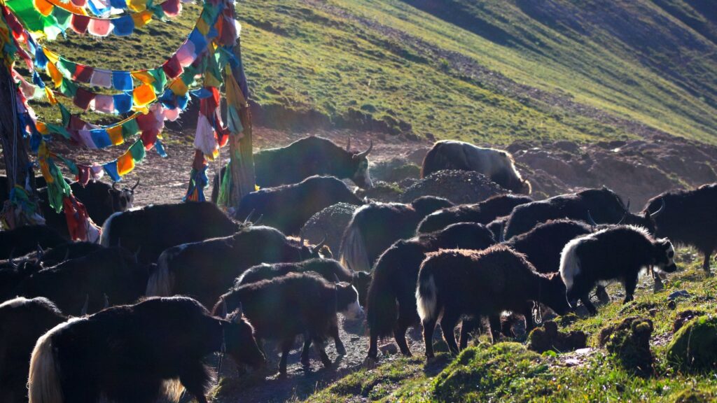
The traditional occupations of nomadic pastoralism and agriculture are still the backbone of Kham society. A major part of their daily food intake is Tsampa made from barley flour, and most eat meat due to the high altitude.
All areas of Tibet are amazing and beautiful. Still, Kham is one of the best regions and offers amazing scenery such as the nomadic grasslands, the glaciated peaks, the alpine lakes, the evergreen forests, and the deep river valleys. Equally amazing is the culture, and some of the best-preserved Tibetan cultural areas are located in Kham. It is not the “cup of tea” region, but it is well worth the effort to get there.


